Learning Resources 1
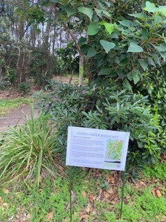
Northern Beaches Council – Careel Bay Bushland Reserve
This website provides authoritative information about the ecological significance of Careel Bay Bushland Reserve, including details about mangrove ecosystems and conservation initiatives. It supports students in understanding the local context of the field visit and reinforces geographical concepts such as environment and interconnection. Teachers can use this source to introduce factual background prior to the excursion and to consolidate learning afterwards. As a local government resource, it strengthens place-based learning by connecting classroom inquiry to authentic community management practices.
NSW Department of Planning & Environment – Mangroves in NSW
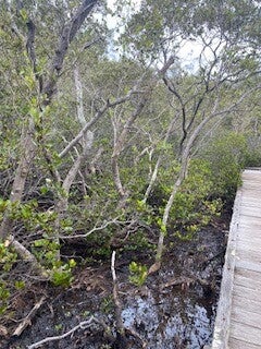
This government resource explains the ecological functions of mangroves, including shoreline protection, habitat provision, and water filtration. This resource uses text, maps, photographs and tables to explain the function of the wetland environment. It supports students in identifying cause-and-effect relationships within wetland systems, directly reinforcing Stage 2 outcomes related to environmental characteristics and interactions. The clear diagrams and accessible explanations make complex ecological processes understandable for primary learners. Teachers can use this to extend observational learning from the site visit into deeper conceptual understanding of ecosystem interdependence.
What are Mangroves?
This short 3 minute multimedia clip introduces wetlands through engaging visuals and simplified scientific explanations. It is particularly effective for supporting a range of diverse students and multimodal learners, as it combines narration, imagery, and animation. Teachers can use this before the excursion to activate prior knowledge, or afterwards to clarify concepts observed at Careel Bay. The video will strengthen the students’ ability to connect their local observations and experiences to the broader Australian wetland systems, reinforcing geographical scale and interconnection.
Google Earth
Google Earth allows students to examine Careel Bay from a spatial perspective, enhancing mapping and geographical skills. Students can zoom out to view the broader Northern Beaches coastline, identifying land use patterns and surrounding development. This resource supports spatial thinking and deepens understanding of how the mangrove ecosystem fits within larger environmental systems. It also promotes digital literacy and critical thinking as students compare satellite imagery with their on-site observations.